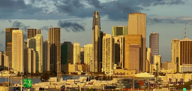
Miami becomes much easier to plan when you stop treating it as one continuous beach city. The destination is a collection of mainland neighborhoods, bayfront districts, causeway crossings, barrier-island communities, cultural institutions, beaches, and protected water. A rewarding first visit does not need to cover all of them. It needs a sensible base, a few geographic clusters, and enough open time for heat, rain, traffic, and the unexpected discoveries that make a city feel like a place rather than a checklist.
This guide builds a first trip around that logic. It explains the difference between Miami and Miami Beach, compares four useful planning bases, outlines a three-day route, and adds an optional Biscayne nature day. It also separates the area’s transit systems, highlights basic beach and weather safety, and shows where to leave room for museums, food, architecture, and neighborhood life. Use it as a framework, then confirm current conditions with official transit, attraction, park, beach-safety, and weather sources shortly before each day.
Begin with the map: Miami and Miami Beach are different places
The City of Miami sits mainly on the mainland. Miami Beach is a separate municipality on a barrier island across Biscayne Bay. Causeways connect the two, but a short distance on a map can become a meaningful transfer once you include walking to a stop, waiting, traffic, parking, or a rideshare pickup. This is the planning fact that prevents many first trips from becoming a series of cross-bay commutes.
Downtown Miami, Brickell, Little Havana, Coconut Grove, Historic Overtown, Wynwood, the Design District, and Little Haiti are mainland areas with distinct histories and street patterns. South Beach, Mid Beach, and North Beach are within Miami Beach. Neither side is a complete substitute for the other. The beach side offers direct access to the Atlantic, coastal walking, and a concentration of Miami Beach architecture. The mainland offers rail connections, bayfront museums, civic history, older neighborhoods, major arts districts, and different kinds of daily street life.
Plan in clusters, not by a single “must-see” ranking
Think of each day as a cluster with one primary area and, at most, one compatible secondary area. Downtown’s bayfront institutions work naturally together. South Beach architecture and beach time belong together. Little Havana and Coconut Grove can share a day if you keep the stops selective and allow for the transfer. Biscayne National Park is a separate nature commitment rather than an add-on between city attractions.
This approach leaves space to notice the details that distinguish Miami: shade under a deep awning, limestone and terrazzo surfaces, a working waterfront, a neighborhood bakery, a courtyard, music from an open doorway, mangroves at the edge of the bay, and the sudden change in light after a rain shower. For more ways to group interests, browse the Things to Do, Neighborhoods, and Arts and Culture collections.
Choose a base that supports the trip you actually want
Your accommodation location shapes every day more than any individual attraction choice. Before comparing properties, decide whether the trip should begin with the ocean, the downtown transit network, a quieter bayfront neighborhood, or a culturally focused mainland itinerary. The Where to Stay in Miami guide can help with a deeper comparison; the short version below is enough to choose a planning direction.
South Beach: choose it for walkable beach-and-architecture days
South Beach makes sense when Atlantic beach access, early shoreline walks, Ocean Drive’s historic district, and a lively pedestrian environment are central to the visit. Staying here can reduce daily friction for beach-focused travelers because the first activity may be outside the door. The tradeoff is that mainland museums and neighborhoods require a causeway crossing. A beach base should not be paired with an ambitious list of mainland stops every day.
Downtown or Brickell: choose it for transit and mainland connections
Downtown and Brickell are useful for travelers prioritizing bayfront museums, central-city architecture, rail access, and day trips that begin on the mainland. The free Metromover circulator serves the greater downtown area, while Metrorail connects selected parts of the county. These districts are practical bases, but the dense skyline should not be mistaken for a complete picture of Miami. Build neighborhood and nature time into the itinerary.
Coconut Grove: choose it for a lower-key bayfront rhythm
Coconut Grove offers tree canopy, historic layers, bay proximity, and a more residential scale than the downtown core. It suits visitors who prefer a quieter return at the end of the day and who want Vizcaya Museum and Gardens, local streets, or the waterfront to anchor part of the trip. It is less convenient for a traveler who expects to walk to South Beach or move between distant nightlife areas without planning transportation.
Little Havana: treat it as a focused day cluster
Little Havana is essential to understanding contemporary Miami, but first-time visitors do not need to use it as an accommodation base to give it meaningful time. Plan a deliberate visit centered on Calle Ocho and the surrounding streets, then slow down enough to notice civic spaces, food traditions, music, memorials, and ordinary neighborhood activity. Avoid treating the area as a themed entertainment strip or reducing Cuban Miami to cigars, cocktails, and souvenirs.

| Planning cluster | A good fit when you prioritize | Connections to plan |
|---|---|---|
| South Beach | Atlantic beach time, historic Miami Beach architecture, and a walkable coastal day | Causeway travel for Downtown, Brickell, Little Havana, Coconut Grove, and mainland museums |
| Downtown / Brickell | Bayfront institutions, Metrorail access, Metromover circulation, and a central mainland base | A causeway crossing for Miami Beach and separate transfers for neighborhoods beyond the rail spine |
| Coconut Grove | Tree-lined streets, bayfront atmosphere, Vizcaya, and a quieter evening base | Planned travel to South Beach, Downtown, and northern arts districts |
| Little Havana day cluster | Cuban American history and culture, Calle Ocho, food, music, and public life | A focused visit paired carefully with one nearby mainland area rather than several distant stops |
Getting around: understand the systems before combining them
Miami’s transportation network is useful when each service is matched to the right geography. It becomes confusing when every train, circulator, and trolley is treated as one seamless system. The Miami Public Transportation guide provides a fuller planning overview, but four distinctions matter immediately.
- Metrorail is the county’s elevated rail system. It serves a defined corridor rather than every visitor district. Check the official route map before choosing a hotel on the assumption that a station reaches a specific beach or neighborhood.
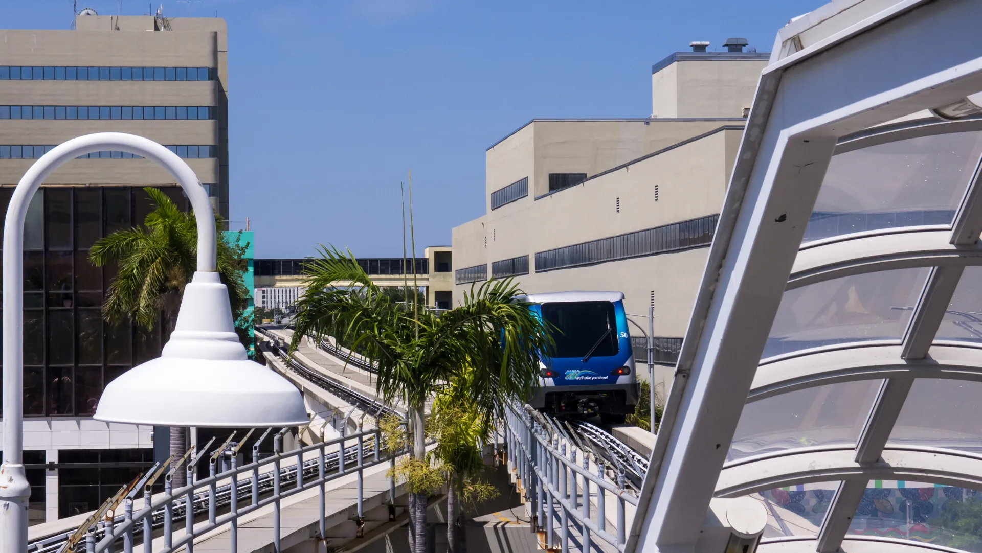
- Metromover is a separate, free circulator serving the greater Downtown and Brickell area. It is especially useful for linking downtown stops, but it does not cross Biscayne Bay to Miami Beach.
- The Miami Beach trolley is a municipal service within Miami Beach. Its route information belongs to Miami Beach, not to the City of Miami trolley network.
- The City of Miami trolley serves routes on the mainland. Do not assume that a trolley with “Miami” in its name crosses to Miami Beach.
Transit details can change, and maps from third-party planning apps may lag behind temporary service conditions. Before leaving, check the relevant official agency or city source for the route, operating status, accessibility information, and any alerts. This article intentionally omits fares and hours so it does not turn a planning framework into stale instructions.
Build a realistic daily movement plan
A useful route sheet contains fewer details than many travelers expect. Record the first major stop, the cluster for the day, the likely mode between clusters, and one fallback if weather changes. Avoid scheduling timed entries at opposite sides of the bay with a narrow transfer window. If driving, include parking research in the plan rather than assuming a space will appear near the entrance. If using a rideshare, confirm the pickup point before stepping into traffic or blocking a transit stop.
- For each day, note:
- one primary neighborhood or district;
- one indoor option for heat or rain;
- one planned cross-city transfer at most;
- the official source you will check that morning.
- Carry what supports flexible movement:
- water and sun protection;
- a light rain layer or compact umbrella when conditions warrant;
- a charged phone and an offline note with the accommodation address;
- footwear appropriate for both walking and wet pavement.
A practical three-day first-time Miami route
This route is a sequence, not a schedule. It deliberately alternates a mainland bay day, a Miami Beach day, and a neighborhood day. Reverse the order to match weather, museum availability, or where you stay. Confirm admission policies and current visitor information directly with each institution before making firm plans.
Day 1: Downtown, the bay, and Miami’s civic story
Begin on the mainland, where the relationship between the city and Biscayne Bay is easy to read. A bayfront walk provides spatial context: Miami Beach lies across the water, port and bridge infrastructure shape the view, and the downtown skyline rises from a low subtropical coast. This is a better introduction than racing directly from the airport to a list of isolated landmarks.
Choose one major museum pair or one museum plus an outdoor segment. Pérez Art Museum Miami and the Phillip and Patricia Frost Museum of Science occupy the Museum Park area and can form a coherent cultural cluster. HistoryMiami Museum, in the downtown civic area, offers another way to understand the region’s development, migration, and communities. Trying to absorb all three deeply in one day may be less useful than selecting according to your interests and leaving time to walk between urban spaces.
Use Metromover selectively for downtown connections, but keep looking at street level. The movement from waterfront park to civic center, older commercial blocks, towers, and transit structures shows several versions of Miami in a compact area. If energy remains, add a brief Brickell segment rather than another distant neighborhood. End the day by reviewing the next morning’s beach flags, weather outlook, and transportation plan through official sources.
Day 2: South Beach architecture and ocean safety
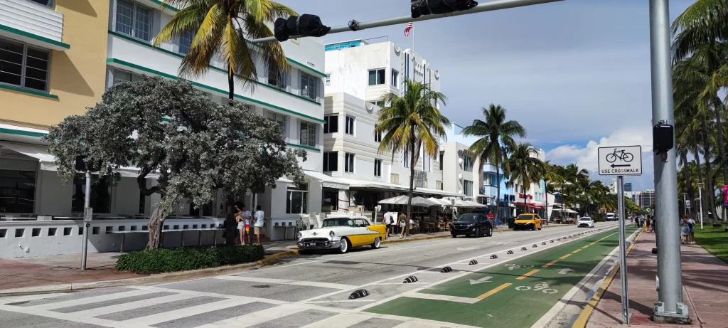
Give Miami Beach its own day. Start with the built environment while the day is manageable: look for horizontal bands, rounded corners, shade structures, porthole-like openings, terrazzo, and the contrast among Tropical Art Deco, Mediterranean Revival, and later postwar buildings. The Miami Beach Guide expands this route and keeps the architecture connected to the wider community rather than presenting a single photogenic street as the whole city.
Historic architecture should be read as a district, not a backdrop for traffic-lane photography. Stay on public paths, respect active hotels and residences, and do not enter roads for a symmetrical image. Look at upper floors, side streets, shaded entries, and the way buildings respond to sun and salt air. If joining an architectural walk, use current information from the relevant preservation or visitor organization instead of assuming a recurring tour is operating.
Pair architecture with a beach segment, but treat the ocean as an active natural environment. Swim near a lifeguard when available, read the posted flag system, follow lifeguard instructions, and do not assume calm-looking water has no current. Keep children and less-confident swimmers within close supervision. Alcohol, fatigue, and unfamiliar surf conditions are a poor combination.
Florida thunderstorms can develop quickly. If thunder is audible, leave the beach and seek a substantial enclosed shelter; a shade umbrella, lifeguard stand, or open pavilion is not lightning protection. Follow official beach closures and local emergency guidance, and wait for the all-clear rather than using a patch of blue sky as evidence that danger has passed. Heat is another reason to alternate exposed walking with shade, water, and indoor breaks.
Day 3: Little Havana and Coconut Grove
Use the third day to move from a culturally specific urban neighborhood to one of Miami’s older bayfront communities. Begin in Little Havana with a focused Calle Ocho area walk. Seek context before consumption: notice memorials and gathering places, learn why particular public spaces matter, and recognize that the neighborhood is a living home and business district rather than a set built for visitors.
Food can provide a generous entry point when approached with curiosity and restraint. A coffee window, bakery, fruit stand, or family restaurant is not evidence that one meal represents all Cuban or Cuban American life. Ask simple questions when staff have time, pronounce place and dish names with care, and avoid turning people at work into uninvited photo subjects. The Food and Drink collection offers broader planning ideas across Miami’s many communities.
Continue to Coconut Grove only after allowing enough time for the transfer. In the Grove, shift the pace. Tree canopy, residential streets, bayfront spaces, and older architecture create a different relationship between tropical climate and city form. Vizcaya Museum and Gardens can anchor the second half of the day, but confirm current entry procedures and site guidance before arrival. Treat the house, collections, gardens, and waterfront setting as a connected historic landscape, not merely an ornate photo stop.
If the day already feels full, choose either a deeper Coconut Grove walk or Vizcaya rather than forcing both. A first trip benefits from contrast, but contrast only registers when there is time to observe it. Return to your base before adding an evening plan in another distant district.
Optional Day 4: make Biscayne National Park a real nature day
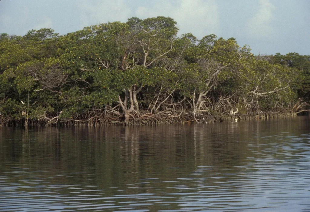
Biscayne National Park protects a landscape that is approximately 95 percent water. Its connected environments include mangrove shoreline, the shallow bay, keys, and coral reef. That geography changes how a visit works. It is not a conventional drive-through park where most major features sit beside a loop road, and it should not be squeezed between a museum and a beach afternoon.
Start by deciding what kind of park day you want. A mainland shoreline visit can introduce the bay and mangroves. Reaching offshore keys, reefs, or many on-water experiences generally depends on a boat and on current conditions. Boat-dependent access requires more preparation than simply arriving at a visitor center. Review the National Park Service’s current operating information, safety guidance, weather notices, and access details before leaving Miami.
The Biscayne National Park from Miami guide separates shoreline, paddling, boat, and underwater possibilities so travelers can choose without inventing access that does not exist. Any commercial activity should be considered only through legitimate current operators and official guidance; this article does not recommend, price, rank, or display provider inventory.
Visit with ecological context
Mangroves, seagrass, bay shallows, keys, and reef are related systems, not decorative scenery. Avoid touching coral or wildlife, standing on sensitive underwater habitat, feeding animals, leaving fishing line, or treating clear shallow water as consequence-free. Use reef-safer behavior, follow park rules, pack out what you bring, and listen to trained staff about conditions beyond the shoreline.
A nature day also needs a cancellation mindset. Wind, storms, water conditions, heat, or operator decisions can change what is safe. Build a mainland alternative into the itinerary and accept that an offshore plan may not proceed. That flexibility is responsible trip design, not a failed day.
Six rules for a first Miami itinerary that can survive the real day
- Give each day one geographic anchor. Make Downtown, South Beach, Little Havana, Coconut Grove, or Biscayne the day’s primary idea. A secondary area should support that idea rather than compete with it.
- Cross the bay deliberately. A causeway journey is not automatically difficult, but it is a real transfer. Group beach-side stops together and mainland stops together.
- Keep a weather-ready alternative. For every exposed plan, identify an indoor or shaded option:
- a museum or cultural institution for a stormy period;
- a slower meal or café break during peak heat;
- a neighborhood walk that can be shortened without losing the entire day.
- Verify changing details at the source. Check official transit agencies, cities, attractions, the National Park Service, beach-safety authorities, and weather services. A saved screenshot or old blog post may not reflect today’s conditions.
- Leave cultural neighborhoods unflattened. Learn names and context, support businesses respectfully, ask before photographing people, and do not use one community as a colorful transition between “main” attractions.
- Protect unstructured time. A shaded bench, unexpected exhibition, long lunch, or waterfront pause can reveal more than an additional cross-city stop. Leave at least one part of each day adjustable.
Weather, heat, rain, and hurricane-season planning
Miami’s subtropical climate should shape the structure of a day. Heat and humidity can make an exposed midday route feel very different from the same distance in the morning. Rain can be localized and intense. Thunderstorms bring lightning risk even before heavy rain reaches the beach. A forecast is a planning input, not a guarantee, so pair it with live official alerts and visible conditions.
Design the day around exposure
Place long architecture walks, open shoreline time, and unshaded parks earlier when practical, then reserve indoor institutions or a slower meal for the most exposed part of the day. Hydrate regularly, use sun protection, and recognize early signs of heat stress. Clothing that dries comfortably and footwear with dependable traction are more useful than an outfit planned only for photographs.
Treat hurricane information as a safety decision, not travel drama
Atlantic hurricane season overlaps with many travel dates, but a seasonal label is not a forecast for a particular trip. As the date approaches, monitor official weather and emergency-management information. Know the accommodation’s communication method, understand airline and lodging change policies, and keep essential documents and medicines accessible. If local authorities issue evacuation or shelter instructions, follow them promptly. Do not drive toward flooded roads, closed bridges, or coastal areas to watch conditions.
The Miami Weather Planning guide provides an evergreen checklist without attempting to predict a specific visit. Travelers who need accessibility, medical, or mobility support should plan extra lead time for any weather-related change and discuss relevant arrangements directly with their accommodation and transportation providers.
Food, culture, and neighborhood photography without the shortcut
Miami’s cultural life reflects Cuban, Haitian, Bahamian, Black American, Jewish, Caribbean, Central and South American, Indigenous, and many other histories and communities. Those experiences overlap, but they are not interchangeable. A first visit should resist the urge to summarize the city with one dish, one mural, one music style, or one broad label such as “Latin flavor.”
Choose neighborhood stops because you want to understand their specific context, not because they provide visual variety for a social feed. Read a museum panel, historic marker, cultural center page, or locally produced guide before arriving. Spend at businesses as a customer, not as a collector of “authentic” moments. Ask permission before making a recognizable portrait. Murals and artworks may be copyrighted even when they face a public street, so do not assume every photograph is available for commercial reuse.
At restaurants and cafés, follow the same principle used elsewhere in the itinerary: choose a cluster, allow time, and avoid chasing distant recommendations between every meal. A good food plan might combine one researched destination with flexible nearby options. It does not need a ranking, a review score, or a claim that one place is the definitive version of an entire cuisine.
What to reserve, what to leave flexible, and what to check again
Some parts of a Miami trip may require advance decisions, while others are better protected from over-planning. The goal is not to avoid reservations; it is to reserve only what shapes the day, then leave room around it. The Tours page is the appropriate place to review live provider-owned experiences if and when the site’s authorized integration returns them. This article does not reproduce or simulate that inventory.
- Consider arranging ahead:
- accommodation in the cluster that suits the itinerary;
- a museum or historic site when its official visitor information recommends timed entry;
- a legitimate boat-dependent park experience after checking access and cancellation terms;
- mobility accommodations or accessible transportation that require notice.
- Keep flexible:
- the order of outdoor and indoor stops;
- a neighborhood meal without a rigid cross-city deadline afterward;
- one afternoon or evening segment that can absorb weather or fatigue;
- the exact length of a beach or waterfront visit.
- Recheck shortly before use:
- transit routes, service alerts, and accessibility;
- attraction admission procedures and closures;
- beach flags, lightning risk, marine conditions, and park notices;
- official emergency and weather information.
First-time Miami questions
Is Miami Beach the same as Miami?
No. The City of Miami and the City of Miami Beach are separate municipalities, with Biscayne Bay between the mainland and the barrier island. They are connected by causeways, and both are part of the wider destination visitors commonly call Miami. Plan beach-side and mainland clusters separately enough that crossing the bay does not dominate every day.
Can a first-time visitor explore without a car?
Many visitors can build a trip around walking, Metrorail, Metromover, municipal trolleys, buses, taxis, and rideshares, but the answer depends on the accommodation base and selected clusters. No single service reaches every visitor area. Compare the actual route between your accommodation and priority stops using current official sources, and include accessibility and late-return needs in the decision.
How many neighborhoods should fit into one day?
One primary neighborhood or district, plus one compatible secondary area, is a practical first-trip rule. More may fit geographically, but a long list often replaces observation with transfers. A Downtown museum-and-bay day, a South Beach architecture-and-ocean day, and a Little Havana-and-Coconut Grove day each have a readable theme.
Is South Beach enough for a first Miami trip?
South Beach can fill a satisfying coastal day, but it does not represent the full destination. A first visit gains depth from at least one mainland cultural or neighborhood cluster and, when time and conditions allow, a bay or nature perspective. The point is not to collect districts; it is to understand that Miami’s identity spans street, bay, island, and ocean.
Can Biscayne National Park be added for a few hours?
A limited mainland shoreline visit may fit a shorter window, but much of the park is water and many offshore experiences depend on a boat, conditions, and current operating information. Treat a meaningful on-water plan as its own day commitment. Keep a safe alternative in case weather or access changes.
What should change when rain or lightning develops?
Move from exposed beaches, water, open parks, and unsheltered walks to a substantial enclosed location, following official local guidance. Thunder means lightning is close enough to require action. Do not shelter under a beach umbrella or isolated tree. Use the indoor alternative already attached to the day’s cluster and wait for authoritative safety information before resuming.
A final first-trip checklist
- Choose a base by geographic priorities, not by a generic “central” label.
- Give Miami Beach and the mainland enough time to feel distinct.
- Keep most days to one anchor cluster and one compatible addition.
- Know the difference among Metrorail, Metromover, the Miami Beach trolley, and City of Miami trolley routes.
- Confirm current official information without relying on saved fares, schedules, or old screenshots.
- Read beach flags, respond promptly to thunder, and plan for heat and rain.
- Treat Biscayne National Park as a water-shaped landscape with boat-dependent offshore access.
- Enter cultural neighborhoods with context, patience, and permission-aware photography.
- Leave one adjustable part in every day.
A first Miami trip does not need to solve the whole city. It needs to reveal the relationships that make the place distinctive: mainland streets beside Biscayne Bay, historic architecture facing an active ocean, cultural neighborhoods connected but not interchangeable, and dense urban life within reach of mangroves, keys, and reef. Plan those relationships well, and the itinerary can move from streetlight to saltwater without rushing past everything in between. Continue with the latest planning articles on Guides.
Still comparing Neighborhood By Neighborhood?
Ask for tour ideas, hotel suggestions, or a simple trip plan that combines both.